Alaska Highway – The MILEPOST
The MILEPOST® Quick Reference Log
Miles from Dawson Creek (DC) shown.
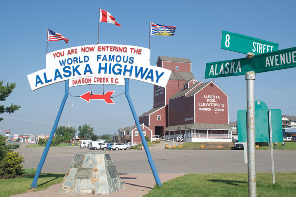
DC 0 Mile O in DAWSON CREEK (pop. 11,800); all services. Visitor information. Mile 0 Post is downtown at 10th Street and 102nd Avenue, Alaska Highway monument is adjacent the grain elevator.
DC 1.5 Mile 0 Park; camping. Campground is adjacent Walter Wright Pioneer Village.
DC 17.3 Exit east for loop road to Kiskatinaw Provincial Park (3 miles/5 km); camping. Also access to Historic Kiskatinaw River Bridge, the original Old Alaska Highway wooden bridge.
DC 34.4 Peace River Bridge, longest water span on the Alaska Highway.
DC 35 TAYLOR (pop. 1,300); food, gas, lodging, camping. Visitor information at the Visitor Centre on the Alaska Highway; stop and photograph the Gold Panner statue. World’s Invitational Gold Panning Championship in August.
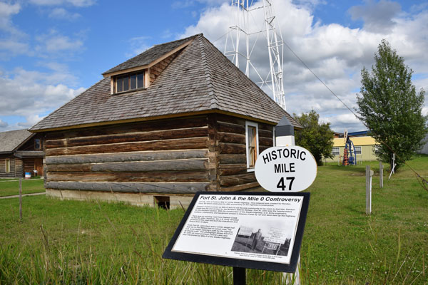
DC 47 FORT ST. JOHN (pop. 21.523); all services. Food, gas and lodging are located on frontage roads along the Alaska Highway and in downtown Fort St. John. Visitor information is located inside the Pomeroy Sport Centre at 9324 96 Street.
DC 51 Turnoff for Charlie Lake day-use area and campground. The Alaska Highway monument here is a memorial to 12 American soldiers working on construction of the Alaska Highway who drowned here in 1942, when their pontoon boat sank while crossing the lake. Camping at adjacent Rotary Park campground.
DC 53.6 Junction with Highway 29 to Hudson’s Hope to west. Turnoff to east for Charlie Lake Provincial Park; camping.
DC 71.7 Historical Mile 72. The Shepherd’s Inn; restaurant (with homemade baked goods), motel, gas/diesel; phone 250-827-3676 or email.
DC 101 WONOWON (pop. 150); food, gas.
DC 140.4 Historical Mile 143. PINK MOUNTAIN (pop. 99); general store, gas/diesel/propane, camping at Pink Mountain Campsite & RV Park, Race Trac Fuels, open year-round; phone 250-772-5133 or email.
DC 159.2 Historical Mile 162. SIKANNI CHIEF. Sikanni River Campground & RV Park; seasonal gas, lodging and camping.
DC 173.3 Buckinghorse River Wayside Provincial Park, camping.
DC 173.4 Historical Mile 175. Buckinghorse River Lodge to west; seasonal 24-hour public cardlock AFD gas pump.
DC 227 Historical Mile 233. PROPHET RIVER; no services
DC 265.5 Andy Bailey Regional Park 7 miles/12 km east; camping.
DC 280 Ye Olde Quilt Shoppe has quilting supplies; phone 250-774-2773 or email.
DC 281.2 Muskwa River bridge, lowest point on the Alaska Highway at elev. 1,000 feet/305m.
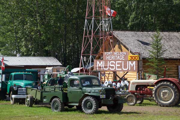
DC 283 Historical Mile 300, FORT NELSON (pop. 6,147); all services. Lodging at Woodlands Inn & Suites and Ramada Limited (email); groceries and natural foods at Down to Earth Heath Shop; RV/vehicle servicing at Dalex Auto, and Al’s Car Clean & Repair (phone 250-774-4931). Visitor information: Inside the Northern Rockies Regional Recreation Center, across the highway from the museum; free dump station. Camping at Triple “G” Hideaway RV Park; phone 250-774-2340 or email; full hook-up sites, laundry, restaurant (restaurant closes Sept. 30, campground remains open well into October). Fort Nelson Heritage Museum, adjacent Triple G campground, has Alaska Highway history and pioneer artifacts, a very fun stop.
DC 284.7 Junction with south end of Old Alaska Highway and access to Al’s Car Clean & Repair; phone 250-774-4931.
DC 301 Junction with Liard Highway to Fort Liard and Northwest Territories via Deh Cho Route.
DC 344.7 Turnoff for Tetsa River Campground Regional Park.
DC 357.5 Historical Mile 375. Tetsa River Services and Campground; gas/diesel, campground, popular cinnamon bun stop, rustic cabins, horse boarding.
DC 373.3 Historic Milepost 392, Summit Lake; no services. The Summit Lake Lodge has been closed for many years.
DC 373.6 Summit Pass (elev. 4,250 feet/1,295m), highest summit on the Alaska Highway. Summit Lake (Stone Mountain) Provincial Campground. Watch for Stone sheep on the highway.
DC 404.6 Historical Mile 422, TOAD RIVER. Toad River Lodge; food, gas, diesel, lodging, camping. Toad River Lodge is the home of the world famous hat collection.
DC 436.5 Entering MUNCHO LAKE (pop. 29) northbound. Double G Services; lodging, restaurant and gas. Muncho Lake, known for its beautiful deep green and blue waters, is 7 miles/11 km in length, and 1 mile/1.6 km in width; elevation is 2,680 feet/817m.
DC 437.6 Strawberry Flats Campground, Muncho Lake Provincial Park; 15 sites on lakeshore.
DC 442.2 Historical Mile 462. Northern Rockies Lodge; restaurant, gas, lodging, camping. Flightseeing trips of Northern Rockies and Virginia Falls in Nahanni National Park available.
DC 442.9 MacDonald campground, Muncho Lake Provincial Park.
DC 444.9 Muncho Lake viewpoint at Historic Milepost 463.
DC 477.1 Historical Mile 496. LIARD RIVER (unincorporated).
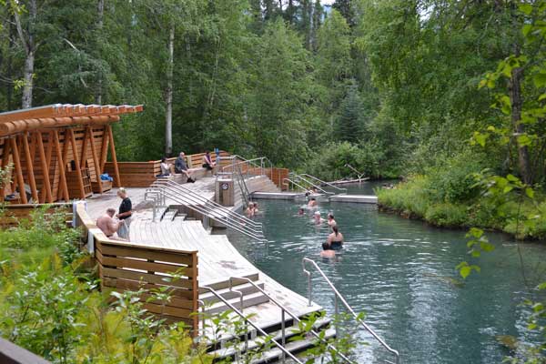
DC 477.7 Liard River Hotsprings Provincial Park; camping. A short walk leads to the hot springs pool. Not-to-be missed spot!
DC 477.8 Historical Mile 497. Liard Hotsprings Lodge.
DC 513.9 Historical Mile 533. COAL RIVER. Coal River Lodge & RV; food, gas, diesel, lodging and camping. Open May through September; phone .
DC 524.2 Historical Mile 543. FIRESIDE; no services.
DC 567.9 Historic Milepost 588, Contact Creek, where crews worked from the south and the north met in September 1942, completing the southern sector of the Alaska Highway.
DC 570 Historical Mile 590. CONTACT CREEK. Contact Creek Lodge, phone 867-536-2262 or email; coffee shop, snacks, gas, diesel, car repair, towing. Open year-round.
DC 603.3 Welcome to British Columbia (southbound sign) at BC–YT border.
DC 607 Lucky Lake (picnicking and swimming) and Liard Canyon Recreation Area (hiking trail).
DC 610.5 Historical Mile 632.5. AFD gas/diesel station.

DC 612.9 Historic Milepost 635, WATSON LAKE (pop. 1,563); all services. Visitor information located in the Watson Lake Recreation Centre adjacent the Sign Post Forest. Lodging at Big Horn Hotel and Cedar Lodge Motel. Camping at Downtown RV Park. Dining at Archie’s Kitchen. Attractions: Watson Lake Sign Post Forest, Northern Lights Centre. Junction of the Alaska Highway and the Campbell Highway.
DC 615.3 Watson Lake Yukon government campground and day-use area 3 miles north.
DC 626.2 Historical Mile 649, junction with the Cassiar Highway, which leads 450 miles/723 km south to the Yellowhead Highway 16; gas, diesel, convenience store, camping at junction.
DC 627 Historical Mile 650. Nugget City; restaurant; gift shop with Canadian souvenirs; gas/diesel; lodging in cabins and budget sleeping rooms; RV park with hookups, laundromat, RV wash, showers/restrooms.
DC 651.2 Big Creek Yukon government campground.
DC 695.2 Rancheria Falls Recreation Site; 10-minute walk to falls.
DC 699.4 Turnout at Continental Divide.
DC 709.8 Historic Milepost 733, SWIFT RIVER. No services.
DC 719.6 Swan Lake Rest Area.
DC 752 Morley River Recreation Site; day-use area.
DC 775.5 Viewpoint overlooks Nisutlin Bay Bridge at Teslin.
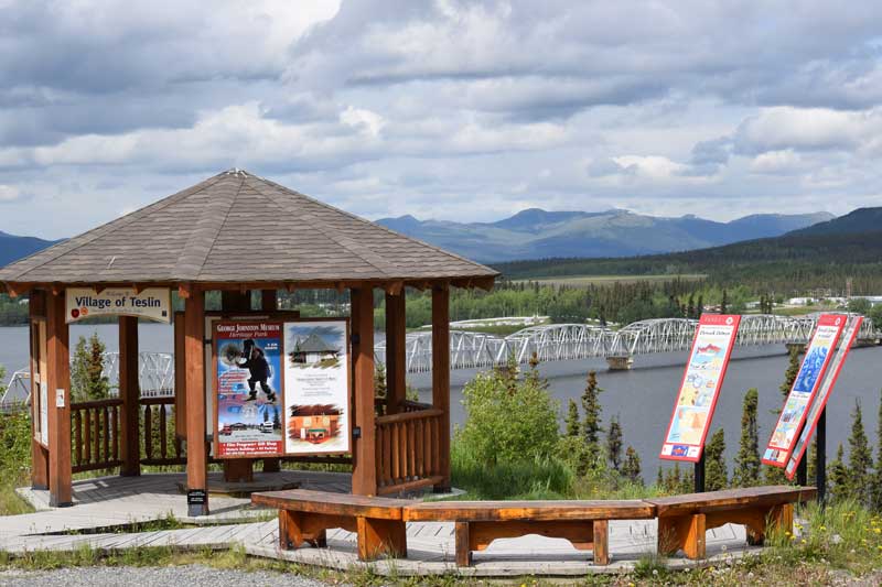
DC 776 Nisutlin Bay Bridge, longest water span on the Alaska Highway.
DC 776.3 Yukon Motel & Lakeshore RV Park; food, gas/diesel, lodging, camping, Yukon Wildlife Gallery, post office. Open year-round (RV Park is seasonal).
DC 776.5 Historical Mile 804 TESLIN (pop. 450); food, gas, lodging, camping. Attractions: George Johnston Museum and Teslin Tlingit Heritage Centre (see next 2 mileposts).
DC 776.7 George Johnston Museum features more than a thousand artifacts reflecting the Tlingit heritage of the area; open June–Sept.
DC 779.1 Teslin Tlingit Heritage Centre highlights inland Tlingit history, open daily June-September.
DC 785.2 Teslin Lake Yukon government campground.
DC 808.2 Junction with Canol Road; rest area. This is the South Canol Road which leads 137 miles/220 km to junction with Campbell Highway near Ross River. The North Canol Road leads from Ross River to the NWT border. Not recommended for tourist travel.
DC 808.6 Teslin River Bridge, third longest water span on the highway.
DC 808.9 Historic Milepost 836, JOHNSON’S CROSSING. Johnson’s Crossing Lodge and RV Park; home-cooked food, baked goods, motel, RV park, WiFi, gas, diesel, gift shop; phone 867-390-2607.
DC 821 Squanga Lake Yukon government campground.
DC 836.8 JAKE’S CORNER; gas/diesel. Junction with Tagish Road which leads 13.4 miles west to TAGISH (pop. 206) on the Tagish/Six Mile River. Also access to Atlin Road (1 mile south of Jake’s Corner), which leads south 58 miles to scenic ATLIN (pop. 350) on Atlin Lake in British Columbia; lodging at Brewery Bay Chalet.
DC 859.9 Historical Mile 890. Marsh Lake Yukon government campground.
DC 867.3 Historic Milepost 897. Yukon River Bridge and Marsh Lake Dam Rest Area.
DC 873.5 Historical Mile 904. The Caribou RV Park, Yukon Motorcycle Park and Wolf’s Den Restaurant; food, camping, hookups, laundromat.
DC 874.4 Historical Mile 905. Junction with South Klondike Highway to Skagway, AK.
DC 876.8 Historical Mile 906. Wolf Creek Yukon Government campground.
DC 880 Historical Mile 910.5. Fireweed RV Services; RV repairs, parts, accessories, phone 867-668-5082.
DC 880.8 Historic Milepost 911. Pioneer R.V. Park; camping, hookups, store, gas, diesel, propane. DC 881 GoNorth Yukon Car & RV Rental, RV Service & Repair and Storage.
DC 881.7 Turnoff for scenic Miles Canyon (pictured at left) via Schwatka Lake Road.
DC 883 Gas, diesel.
DC 883.5 City of Whitehorse rest area.
DC 883.7 Historical Mile 913.4 Junction with Robert Service Way (south access road leads east to Whitehorse city centre) and Hamilton Blvd. access east to Hi Country R.V. Park; full hookups, cable TV, pull-throughs, laundromat, showers
DC 885.7 Historical Mile 915. Attraction: Yukon Beringia Interpretive Centre.
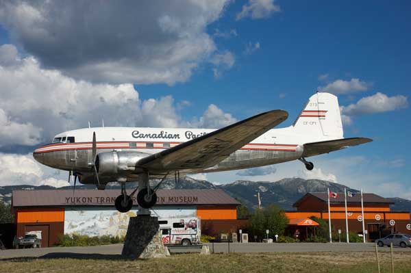
DC 885.8 Lodging and restaurant at signed entrance for Whitehorse Airport. Attraction: Yukon Transportation Museum and Douglas DC-3 weathervane, a Whitehorse landmark.
DC 887.4 Two Mile Hill exit to WHITEHORSE, capital of Yukon; all services and many attractions, both downtown and along the Alaska Highway. Visitor information.
DC 888.3 Gas station, restaurant.
DC 888.7 Copperbelt Mining and Railway Museum.
DC 890.8 Gas, grocery store.
DC 891.1 Gas, convenience store, lodging.
DC 891.4 Motel, gas, convenience store.
DC 891.8 Historical Mile 922. Gas, diesel, motel, restaurant.
DC 894.5 Junction with Klondike Highway 2, the Klondike Loop route to Dawson City and on to Alaska via Top of the World Highway, returning to Alaska Highway east of Tok via the Taylor Highway. Four miles north of this junction, turn on Takhini Hot Springs Road for Takhini Hot Springs, Hot Springs Campground and Hostel and Yukon Wildlife Preserve.
DC 905.4 Historical Milepost 937. Viewpoint with litter bins.
DC 926 Takhini Burn rest area; litter bins, outhouses, viewing platform.
DC 927.3 Historic Milepost 960. Turnoff to south for beautiful Kusawa Lake, a winding dirt and gravel road. Access to Mendenhall Landing point of interest (Mile 1.4); Takhini River Yukon government campground (Mile 9); and Kusawa Lake Yukon government campground (Mile 14.7).
DC 964.7 Historic Milepost 995. Otter Falls Cutoff; restaurant, gas, cabins, gift shop, store, camping. Junction with Aishihik Road to Otter Falls Viewpoint (17.4 miles) and Aishihik Lake campground (26.1 miles).
DC 937.2 Turnoff for First National Community of Champagne (pop. 25). Rest area at Mile 0.2. The Long Ago Peoples Place, a cultural heritage site, at Mile 5 on this side road.
DC 965.6 Historic Canyon Creek Bridge (pictured below); rest area with toilets and interpretive signs.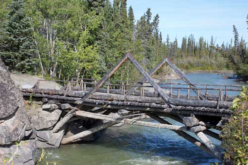
DC 980.8 Yukon government Pine Lake Recreation Park; camping.
DC 982.2 Haines Junction airport.
DC 984.7 Fas Gas & RV Park, gas station (open year-round) with diesel, adjacent The Little Green Apple grocery store, and a summer-only RV park. Across the street is the Da Ku Cultural Centre, home to First Nations Cultural Centre and Visitor Information Centre for Yukon and Kluane National Park; visitor information, restrooms, open daily May–Sept., 8am–8pm.
DC 985 Junction with Haines Highway to Haines, AK, at HAINES JUNCTION (pop. 824), Historic Milepost 1016. Visitor information. Attractions include Our Lady of the Way Catholic Mission (1954) pictured below; the Village Monument; and St. Christopher’s Anglican Church, which hosts the Art & Crafts Guild of Haines Junction (local art, handmade crafts for sale).
Services include food at Guys & Dolls Bistro and the deli at Little Green Apple grocery; accommodations and meals in town at Raven’s Rest Inn; 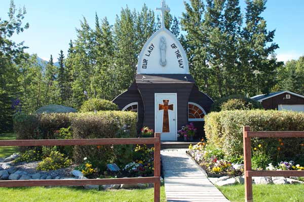 lodging, dining and guided trips just north of town at Mount Logan Lodge; and grocery store at Fas Gas and Little Green Apple; gas and convenience store at Top Spot/North 60˚ Petro Express. Visitor information. Attractions include Our Lady of the Way Catholic Mission (1954) pictured above; the Village Monument; and St. Christopher’s Anglican Church, which hosts the Art & Crafts Guild of Haines Junction (local art, handmade crafts for sale).
DC 985.3 Campground and gas station.
DC 985.9 Gas station and motel.
DC 991.2 Turnoff for Mount Logan Lodge; lodging, food, wilderness tours.
DC 999 Spruce Beetle Trail Interpretive Site.
DC 1000.1 Bear Creek Summit (elev. 3,294 feet), highest point on the Alaska Highway between Whitehorse and Fairbanks.
DC 1003.5 Historic Milepost 1035; Jarvis River bridge; turnout to river to west, good picnic spot.
DC 1020 Kluane Lake Viewpoint.
DC 1024 Large gravel turnout on Kluane Lake. Kluane Lake is the largest lake in Yukon.
DC 1028.8 Tachal Dhal (Sheep Mountain) Visitor Centre; interpretive programs, viewing telescopes. Primary winter and spring range and lambing area for Dall sheep.
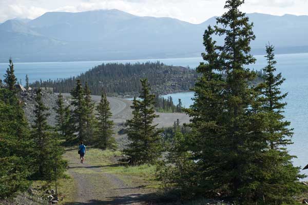
DC 1029.7 Soldier’s Summit, Historic Milepost 1061. Trailhead parking for short hike up to the summit (trail pictured below).
DC 1029.8 Viewpoint overlooking Kluane Lake’s Horseshoe Bay.
DC 1034.5 Historical Mile 1067. Cottonwood RV Park and Campground.
DC 1039.3 Historical Mile 1072. Congdon Creek Yukon government campground.
DC 1050.8 Historic Milepost 1083, DESTRUCTION BAY (pop. 55); food, gas/diesel, and lodging.
DC 1061 Historic Milepost 1093 BURWASH LANDING (pop. 84); gas/diesel at Kluane Energy, which also has a cafe and grocery store. Major attraction here is Kluane Museum of Natural History. The World’s Largest Goldpan—seen below—is in the museum parking lot; good photo op. Kluane  National Park glacier flights are available here from Rocking Star Adventures.
DC 1098.7 Donjek River Bridge.
DC 1117.1 Historical Mile 1152. Lake Creek Yukon government campground.
DC 1123.9 Pickhandle Lake Rest Area.
DC 1133.5 Discovery Yukon Lodgings and RV Park; cabins, rooms, big rig friendly RV sites.
DC 1153.4 Historical Mile 1188. Snag Junction Yukon government campground.
DC 1166.5 Historic Milepost 1202, BEAVER CREEK (pop. 112); Visitor Information Centre open daily in summer, phone 867-862-7321. Traveler services include restaurant, cabins, campground, showers and laundromat at Buckshot Betty’s (open year-round); fuel, gift shop, RV park and motel at Beaver Creek RV Park & Motel; gas and lodging at 1202 Motor Inn.
DC 1168.5 Canadian Customs Beaver Creek station, open 24 hours a day year-round. All traffic entering Yukon must stop.
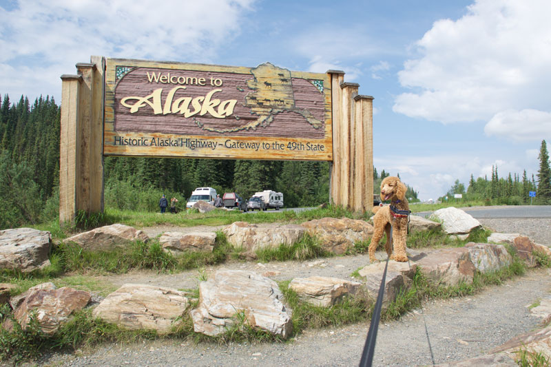
DC 1186.3 Historic Milepost 1221. Canada–U.S. International Border; rest area and photo-op. Welcome to Alaska sign northbound.
The MILEPOST® Log now adds physical mileposts (MP) to log in Alaska.