Alaska’s Good Friday earthquake in shocking images, 1964 – Rare Historical Photos

The rails in this approach to a railroad bridge near the head of Turnagain Arm, southeast of Anchorage, were torn from their ties and buckled laterally by movement of the riverbanks during a massive earthquake on March 27, 1964. The bridge was also compressed and developed a hump from vertical buckling.

On March 27, 1964, at 5:36 PM, a megathrust earthquake occurred in the Prince William Sound region of Alaska. The epicenter was about 10 km east of the mouth of College Fiord, approximately 90 km west of Valdez and 120 km east of Anchorage.

Lasting four minutes and thirty-eight seconds, the magnitude 9.2 earthquake remains the most powerful earthquake recorded in North American history, and the second most powerful earthquake recorded in world history.

Eyewitnesses described hearing a crunching, grinding noise as the earth shook. They recalled seeing asphalt roads rise and fall like waves and the ground opening and closing before them, water shooting up through the ensuing cracks.

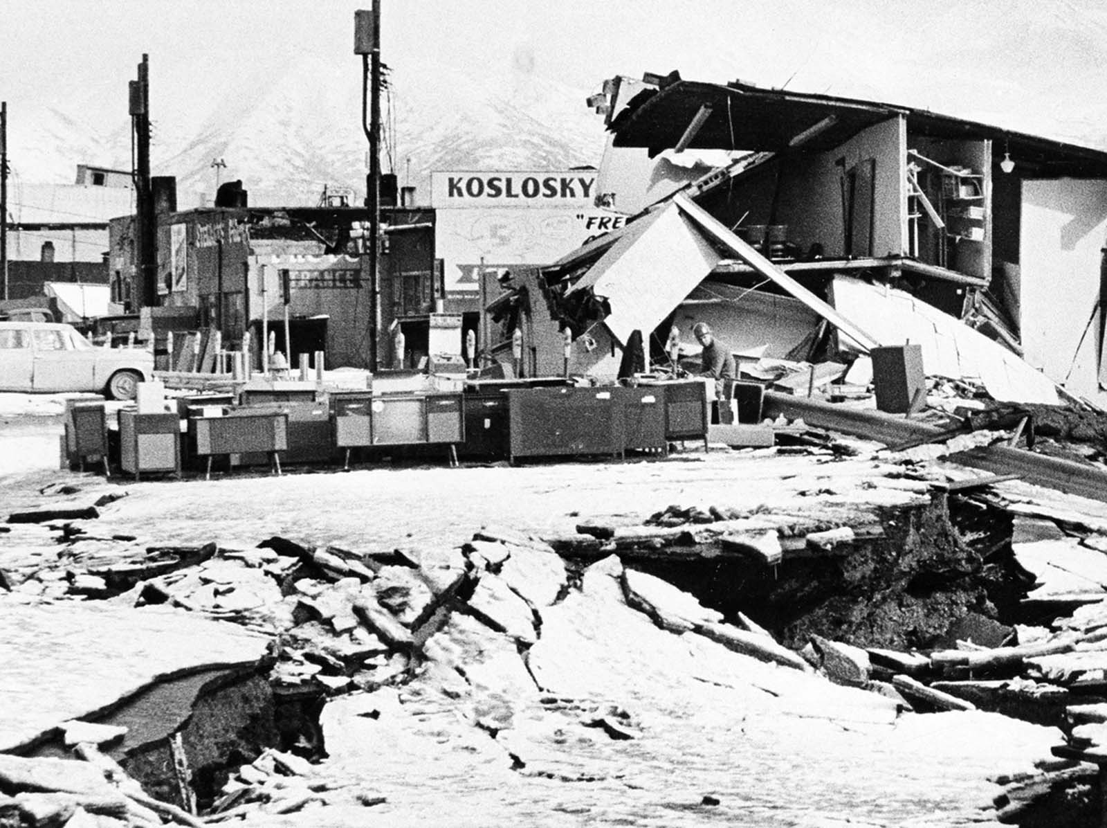
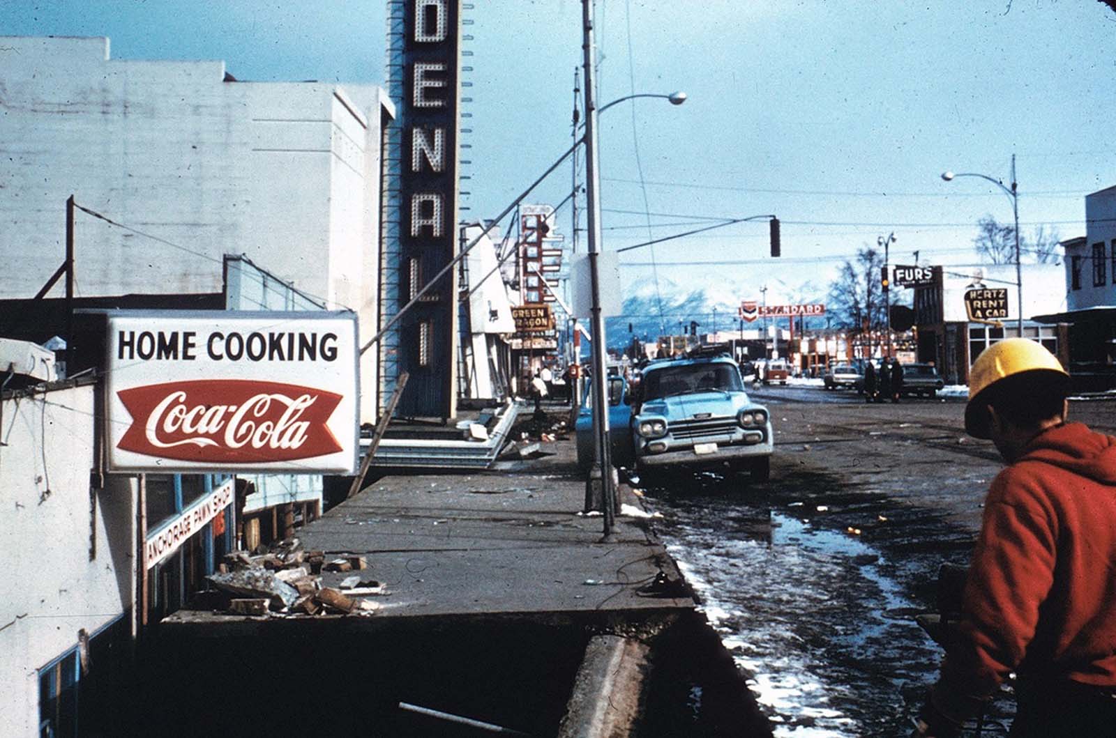
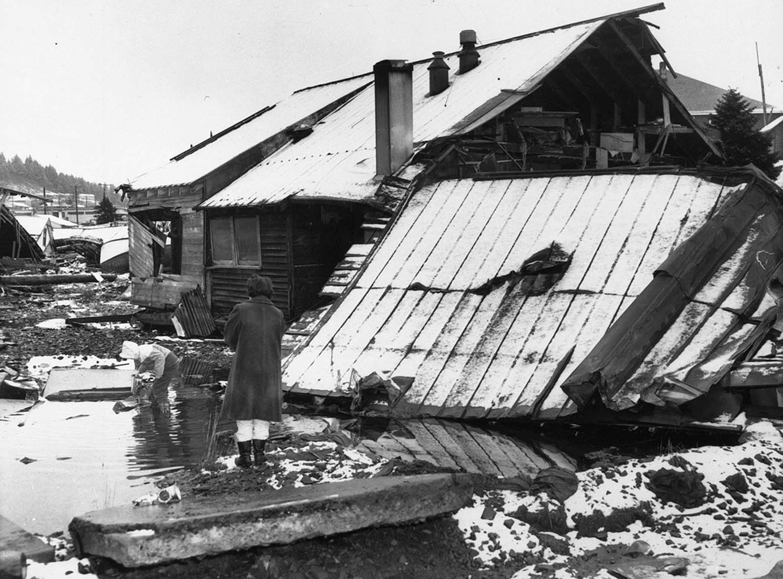
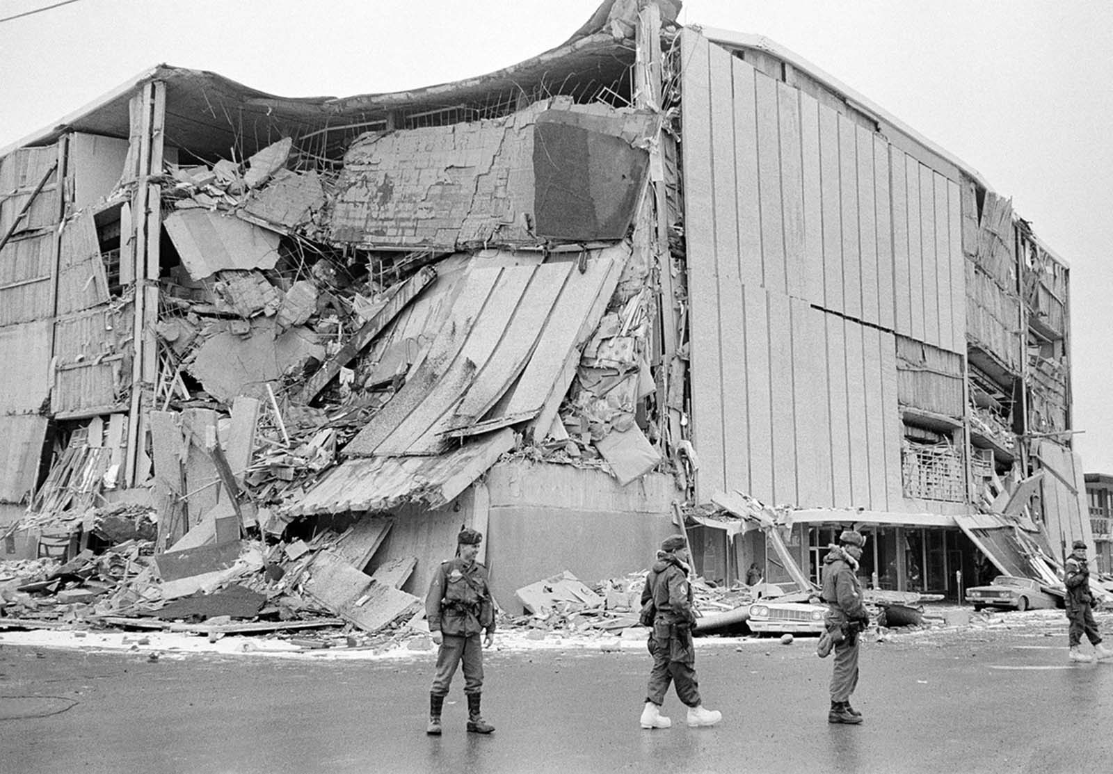
The violent shaking led to water, sewer and gas line breaks and widespread telephone and electrical failures. It effortlessly toppled telephone poles, buckled railroad tracks, split roads in half, uprooted buildings, cars and docks and tore homes apart. Seismic waves caused the earth to “ring like a bell.”

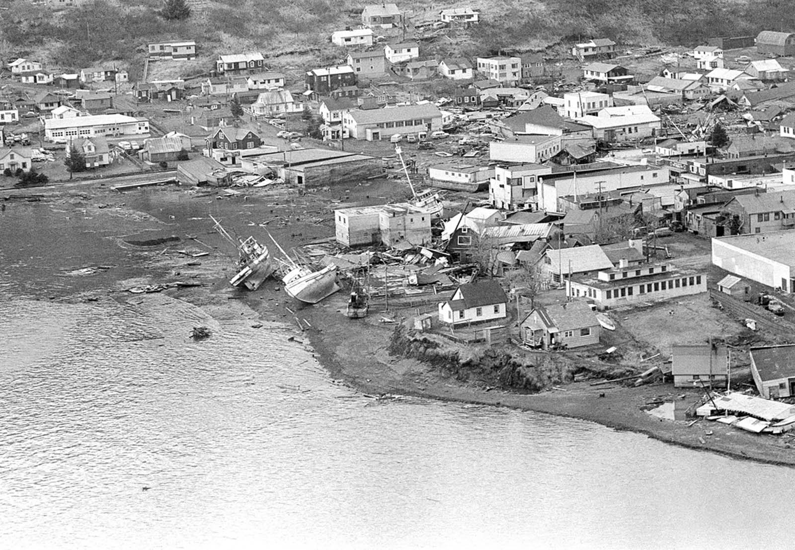
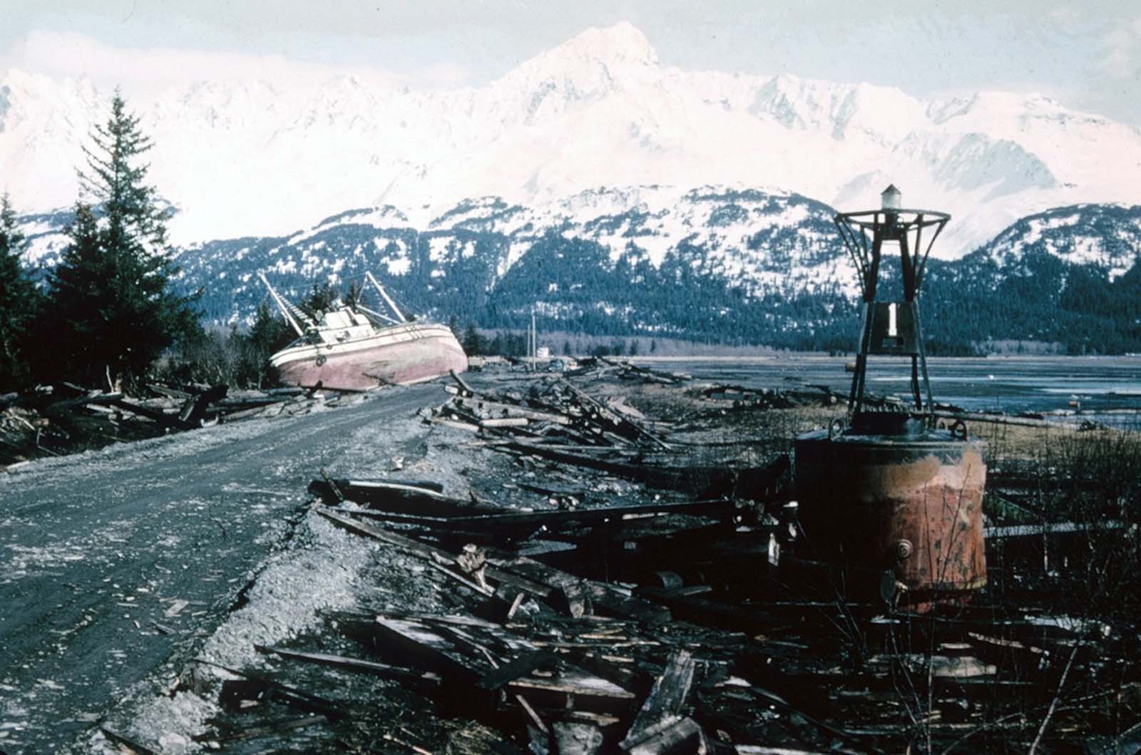
The initial quake and subsequent underwater landslides caused numerous tsunamis, which inflicted heavy damage on the coastal towns of Valdez, Whittier, Seward, and Kodiak. The town of Valdez was originally built on sand and gravel.

A photographer looks over wreckage as smoke rises in the background from burning oil storage tanks in Valdez, Alaska, on March 29, 1964, two days after the earthquake struck.

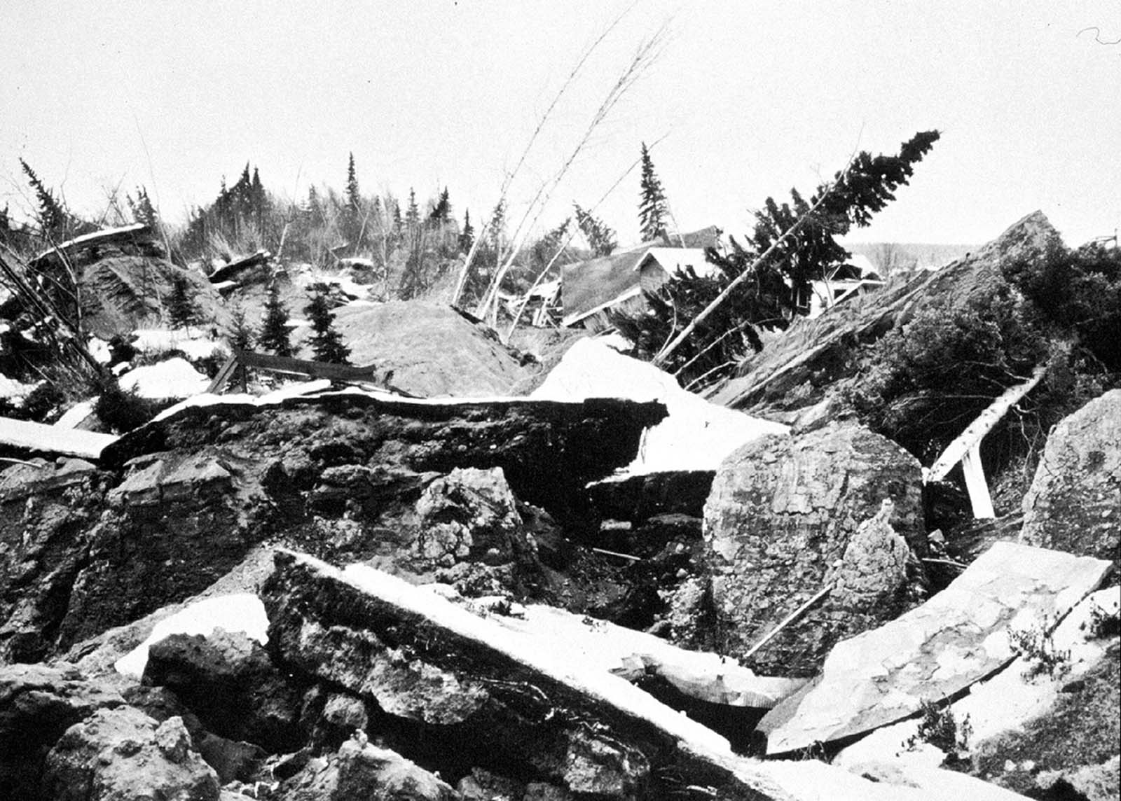
When the earthquake struck, seismic waves caused soil liquefaction and a portion of the delta slumped into Port Valdez, taking much of the port’s resources, living and otherwise, with it.

The delta slump triggered a local tsunami which destroyed almost anything left standing and ruptured the Union Oil Company’s oil tanks, igniting a massive fire.

Valdez was basically leveled, Anchorage sustained great destruction or damage to many inadequately earthquake-engineered houses, buildings, and infrastructure (paved streets, sidewalks, water and sewer mains, electrical systems, and other man-made equipment), particularly in the several landslide zones along Knik Arm.

As a result of the earthquake, 131 people are believed to have died: Nine died as a result of the earthquake itself, 122 died from the subsequent tsunami in places all around the world, five died from the tsunami in Oregon, and 13 died from the tsunami in California.

The quake was a reported XI on the modified Mercalli Intensity scale “indicating major structural damage, and ground fissures and failures”. Property damage was estimated at about $116 million ($0.73 billion in 2018 dollars). It is likely that the toll would have been much higher had the quake not occurred after 5 PM on Good Friday.

Geological surveys taken immediately afterward showed parts of the Alaskan coast sank up to eight feet (2.5m), other parts rose up to 38 feet (11.5m) and much of the coast moved 50 feet (15m) towards the ocean. Coastal forests plunged below sea level and were destroyed by salt water.

Prior to the 1964 Alaskan earthquake, scientists had limited knowledge of what happens far beneath the earth. Afterwards, geologists realized subduction zones—areas where two tectonic plates (huge slabs of rock made of the earth’s crust and upper mantle) meet and one bends under the other—played a major role in creating the immense Alaskan quake.

Scientists learned that at the point where the North American Plate overrode the Pacific Plate, it descended into a subduction zone. According to the United States Geological Survey, “The 1964 earthquake was giant because of the large area of the fault that slipped during the earthquake and the large amount of slip, or relative motion, between opposite sides of the earthquake fault.”

Downtown Anchorage, the collapse of Fourth Avenue near C Street, due to a landslide caused by the earthquake. Before the shock, the sidewalk on the left was at street level with the one on the right.

The dock area, a tank farm, and railroad facilities in Whittier, Alaska were severely damaged by surge-waves developed by underwater landslides in Passage Canal, on March 27, 1964. The waves inundated the area of darkened ground, where the snow was soiled or removed by the waves.The waterfront of Seward, Alaska, weeks after the earthquake, looking north. Note the Smoke rises high into the Alaska sky from burning oil tanks in Whittier, on March 30, 1964.The Four Seasons Apartments in Anchorage was a six-story lift-slab reinforced concrete building which collapsed during the earthquake. The building was under construction, but structurally completed, at the time of the quake.An unidentified man sits at a desk beside hi-fi sets moved to the middle of Fourth Avenue in Anchorage on March 31, 1964. The items were moved from a store that was demolished in the earthquake. The marquee of the Denali Theater sits even with the street in Anchorage. The building's foundation subsided until the marquee came to rest on the sidewalk.The path of destruction made by the quake in Alaska followed by a tsunami can be seen in this aerial view of Kodiak on March 29, 1964. The wave swept in from the lower left and towards upper right, pushing and smashing everything in its way.Chaotic condition of the commercial section of Kodiak following inundation by seismic sea waves. The small boat harbor contained an estimated 160 crab and salmon fishing boats when the waves struck.A view of the destruction of Valdez, Alaska. Thirty-one residents died during the earthquake and subsequent tsunami. Instability and vulnerability to future tsunamis made the old town site too dangerous to rebuild, so the town was relocated several miles west to more stable ground, and rebuilt.Chaos on the waterfront in Seward, burned-out vehicles and rail cars strewn across the ruined rail yard.A mother stands watch as her child plays in a puddle of water near her earthquake-shattered home in Kodiak, Alaska in March of 1964. Tsunami damage and high-water line at Seward. The tsunami waves washed the snow from the lower slopes of the hillsides, and the height of the highest wave is marked by the sharp The roof of a structure dragged into an Alaskan bay after the 1964 earthquake.Support columns punched through the deck of the Twentymile River Bridge, as it collapsed during the earthquake, near Turnagain Arm on Cook Inlet. The adjacent steel railroad bridge survived with only minor damage.Government Hill Elementary School in Anchorage, destroyed by the Government Hill landslide.In an Anchorage neighborhood, a wooden fence at the toe of the L Street landslide, buckled and shortened by compression.An Anchorage neighborhood name Turnagain Heights was partially destroyed by a landslide shortly after the earthquake.The jumbled ground of Turnagain Heights, after the landslide.Damaged homes in the Turnagain Heights landslide area in Anchorage.A wider aerial view of the Turnagain Heights landslide.An earthquake-and-landslide-damaged neighborhood in Anchorage, Alaska.This highway embankment fissured and spread, cracking down the middle. The road was built on thick deposits of alluvium and tidal estuary mud along Turnagain Arm near Portage.The village of Portage, at the head of Turnagain Arm, flooded at high tide as a result of 6 feet of tectonic subsidence during the earthquake.With the city under martial law, soldiers patrol a downtown street in Anchorage, Alaska, on March 28, 1964. In background is the wreckage of the five-story J.C. Penney's store at Fifth Avenue and D Street.Anchorage small business owners clear salvageable items and equipment from their earthquake-ravaged stores on shattered Fourth Avenue, in the aftermath of the quake.The head of the L Street landslide in Anchorage. The land on the left side sank 7 to 10 feet in response to 11 feet of horizontal movement of the lower section of the slide. A number of houses were undercut or tilted by subsidence of the graben. Note also the collapsed Four Seasons Apartment Building and the undamaged three-story reinforced concrete frame building behind it, which are on more stable ground.A man and his wife carry a load of possessions from their earthquake-shattered home in Anchorage, Alaska, on March 31, 1964.A fractured city block in Anchorage, Alaska, on March 28, 1964.One span of the 'Million Dollar bridge' of the defunct Copper River and Northwestern Railroad was dropped into the Copper River by the earthquake.A fishing boat and buoy, washed ashore by tsunami waves in Seward, Alaska.A forlorn couple stands on a concrete dock viewing the remains of the Kodiak waterfront on March 29, 1964.Trees up to 24 inches in diameter and 100 feet above sea level were broken and splintered by the surge wave generated by an underwater landslide in Port Valdez on Prince William Sound.This truck was bent around a tree by the surge waves generated by the underwater landslides along the Seward waterfront. The truck was about 32 feet above water level at the time of the earthquake.

(Photo credit: U.S. Geological Survey).

Alternate Text Gọi ngay